Landslides
Landslides are natural hazards that cause millions of dollars of damage each year and also cause many deaths. They are defined as downslope movements of soil and rock under the influence of gravity. They are triggered primarily by water, but sometimes earthquakes can lead to some spectacular landslides.
Factors
The stability of a slope can be described as two forces working against one another. Driving forces work to cause slope materials to move downslope, whereas resisting forces act to keep the materials on the slope. When the ratio of resisting forces to driving forces (called the factor of safety) is greater than 1, the slope is stable. When it is less than 1, the slope usually fails.
Water and Vegetation.
Water can increase the driving forces and reduce the resisting forces. Saturation from rainfall can increase the slope mass, thereby increasing the driving forces. Filling the slope soil pores with water also reduces soil cohesion by allowing particles to pass by one another, thereby reducing the internal resistance of the soil to sliding. To reduce landslide danger on a slope, the first thing done is to remove the water.
Vegetation also is important to slope stability because it increases resisting forces through its roots, especially tree roots, that bind the soil. Trees also act as natural pumps that remove water from the soils through evapotranspiration , thereby increasing slope stability.
Slope and Materials.
As the slope angle increases, the driving forces also increase. Few landslides occur on slopes less than 15 degrees. Cutting a road into a slope will create an oversteepened slope prone to landslides if a wall is not built. Certain slope materials also have weak strengths and low resisting forces to landslides. For example, clay, shale, serpentine, and uncompacted fill are prone to failure.
If the slope bedrock is inclined and is somewhat parallel to the slope, it is called a dip slope. Landslides are prone along failure planes (clay beds and old soils) on these dip slopes. Examples of dip-slope failure are Italy's Vaiont Dam disaster in 1963 that killed 2,600 people, and the Gros Ventre landslide that dammed Wyoming's Gros Ventre River in 1925.
To stabilize a slope or prevent landslides, one needs to lower the slope angle, drain the slope of water, build retaining walls, plant vegetation, and avoid building on old landslides. If the slope has moved once, it has a high chance of moving again.
Classification
Names are given to different landslides depending upon the process that brings the soil and rock down the slope. Falls are the free fall of detached materials, usually rocks, which descend down a steep slope. Translational slides occur along a failure surface in the bedrock and move parallel to the surface. If the sliding mass occurs along a curved plane, it usually is called a slump.
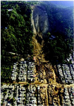
Flows.
Flows occur when material moves downslope as a viscous (thick) fluid. Most of these flows are saturated with water. Fast-moving ones move as a slurry that can be as much as 70 percent water and 30 percent sediment, and these are called debris flows (see figure). If the flow contains mostly fine-grained particles like sand, silt and clay, it is called a mudflow. They frequently follow stream canyons and pose significant hazard to life and property. Velocities can reach 55 kilometers (34 miles) per hour. Earthflows are slower flows that generally originate on hillslopes as large tongues that break away from scarps (arc-shaped steep slopes cut into a hill).
Debris Avalanches.
The fastest and largest landslides are called debris avalanches, because they travel at speeds up to 300 kilometers (186 miles) per hour, travel long distances sometimes in excess of 30 kilometers (18.6 miles), and are very large. The world's largest historical landslide occurred in Washington state when Mount St. Helens erupted in 1980. * In Yungay, Peru, about 22,000 people were killed in 1970 when a debris avalanche descended from the volcano Nevado Huascaran, traveling a distance of 14 kilometers (8.7 miles) in only a few minutes.

Creep.
Some movement on slopes can be imperceptible, called creep. Creep is caused by gravity, and is assisted by freeze–thaw or shrink–swell processes operating on the soil sediments. Rates range from 0.1 millimeter (0.004 inch) per year to 10 centimeters (about 4 inches) per year. Evidence of movement is found in cracked walls, leaning telephone poles, and leaning trees that adjust (straighten) their direction of growth, creating so-called "trees with knees," also called pistol-butt trees.
Recognizing Landslide Terrains
Scientists "read" the landscape for signs that tell of past processes. Several diagnostic landslide features tell of past movement on the terrain. First, scarps are arcuate, steep slopes cut into the hill where the landslide has torn away. Second, hummocky topography is "bumpy" ground that has been produced by the landslide mass-weathering over time. A hummocky slope with a steep, half-moon slope at the top usually means an old landslide occurred there.
Younger landslides generally will have vegetation on the slide mass that is different than vegetation on the surrounding slopes. In coniferous forests, landslides typically are covered with deciduous trees for the first 100 years after the failure.
If one can see the actual sediments making up the landform, landslide debris and colluvium are unsorted, with all particles mixed together in a random fashion. Colluvium can be confused with glacial till, because both are unsorted.
SEE ALSO Forest Hydrology ; Groundwater ; Volcanoes and Water .
Scott F. Burns
Bibliography
Ritter, D. F., Kochel, R. C., and Miller, J. R. Process Geomorphology, 3rd ed. Dubuque, IA: Wm. C. Brown Publishers, 1995.
Turner, A. K., and R. L. Schuster, eds. Landslides: Investigation and Mitigation. Washington, D.C.: Transportation Research Board, National Research Council, Special Report 247 (1996).
* See "Volcanoes and Water" for a photograph of the Mount St. Helens eruption.
i am useing some info for a project so thanks for that!!!!!